Central America
Central America (Spanish: América Central) is a region located between the North American region and South America, geologically and geographically belonging to the North American continent.
The dominant language in Central America is Spanish, the only exception being English-speaking Belize. The population of Central America comes from indigenous people - Indians, as well as from Europeans (mainly Spaniards) and African slaves brought by them.
In political geography, Central America consists of the following states:
Belize
Guatemala
Honduras
Costa Rica
Nicaragua
Panama
El Salvador
The population is 44 million people in 2016, the total area is 521,876 km².
According to the definition of Central America as a macro-region of the UN, in addition to the above countries, Mexico is also included in the region.
In physical geography, Central America is most often understood as a part of the North American continent from the Isthmus of Tehuantepec to the Isthmus of Panama (sometimes the territory is extended beyond both isthmus for various reasons - for example, the northern border is drawn along the border of the Neotropical zone).
Forested lowlands, plains and swamps are located along the coast of Central America. The region is crossed by rivers and mountain ranges. Most of Central America is occupied by the medium-altitude mountains that are part of the Cordillera mountain system (the Sierra Madre South, the Sierra Madre de Chiapas, and others). Heavily fragmented mountain ranges, cut by deep gorges of rivers, sometimes with areas of smoothed plateaus, alternating with tectonic depressions. From the border of Mexico, where the highest peak of Central America rises - the Tahumulco volcano (height 4217 m), to Western Panama from the Pacific side they are joined by the Volcanic Range with many active volcanoes, including those that arose in historical times (Santa Maria, Atitlan, Santa Ana, Cosiguina, Poaz, Irazu etc.). Large lowlands are located only in the north - the accumulative Tabasco and mosquito coast (Mosquito) and the Yucatan Peninsula, composed mainly of limestones with a wide development of karst processes and forms.
In the northern part there are relatively stable blocks of the Central American Massif and the Yucatan Plate, the southern part is occupied by the folded cordillera belt.
The Central American massif is formed by a complex complex of metamorphic rocks of the Paleozoic and, possibly, the Precambrian (Grauwacks, siliceous shales, diabases, amphibolites, gneisses), inconsistently overlapped by Carboniferous-Permian and Triassic-Jurassic continental deposits, as well as Cretaceous limestones. Devonian, Carboniferous and Cretaceous granitoids are widespread.
The Yucatan Plate is an Epipaleozoic platform; consists of a folded base composed of metamorphic rocks, Paleozoic and possibly Precambrian age, and inconsistently overlapping almost horizontal cover of sedimentary rocks of the Mesozoic and Cenozoic (up to 6 km in capacity): red-colored deposits of the Triassic, evaporites and limestones of the Jurassic and Cretaceous, Paleogene-Neogene terrigenic sediments.
The folded belt of the Cordillera in a very reduced form continues the structures of the Cordillera of Mexico; to the southeast of the Isthmus of Tehuantepec, it is separated from the Central American Massif by the advanced Chiapas trough, made by marine and continental deposits of the Paleogene and Neogene. At the base of this belt, the metamorphic folded complex of the Paleozoic is exposed in places, which is blocked in Guatemala by the late Paleozoic molasses. The main place is occupied by Mesozoic, mainly Cretaceous carbonate and flysch strata, containing large bodies of hyperbasites. In the southern regions in the Mesozoic, the products of underwater volcanism of the main composition, formed in oceanic conditions, are widely developed. These areas are characterized by the development of salt domes. The main folding belongs to the Late Cretaceous - Early Paleogene. A band of folded Cretaceous and older rocks forms a gentle arc and extends northeast under the waters of the Gulf of Honduras.
On various more ancient structures is a belt of Neogene and modern volcanoes, which stretches from Mexico to the Panama Canal along the Pacific coast, parallel to the Central American deep-sea trench. Young volcanic and tectonic activity is associated with the formation of the Isthmus of Panama, which separated the Caribbean Sea from the Pacific Ocean.
Of the minerals in Central America, gold and silver ores are known, represented by medium (El Rosario in Honduras) and small (Peace Peace, La Luz in Nicaragua) hydrothermal deposits associated with Cretaceous intrusions and placers (Coco in Nicaragua), as well as small deposits of antimony and mercury. Small deposits of chromites are associated with hyperbasite bodies; with volcanic intrusions of the Neogene - large copper-porphyry deposits of Panama (Cerro Colorado and Cerro Petaquilla). To the salt domes of the Isthmus of Tehuantepec are confined deposits of oil and gas.
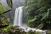
Due to heavy rainfall and the mountainous nature of the relief, annual runoff in Central America usually exceeds 600 mm, reaching 1500 mm or more on the Caribbean slopes of Costa Rica and Panama, only on the southern slopes of the Southern Sierra Madre and in the north-west of the Yucatan Peninsula, the runoff layer is less than 100 mm. The river network is dense, with the exception of the Yucatan Peninsula, almost devoid of surface watercourses. Short, turbulent, rapids predominate; the largest are Motagua, Patuka and Coco. The rivers of the Atlantic Basin are full throughout the year; rivers flowing into the Pacific Ocean are characterized by sharp fluctuations in flow and strong summer floods. In the tectonic basins there are many lakes, including the largest - Nicaragua, Managua, Isabal, Atitlan.
The coast of the Pacific Ocean with a narrow intermittent strip of coastal lowland in the northern part is straight, in the southern part it is strongly dissected by bays (Fonseca, Nicoya, Chiriqui, Montijo, Panama, etc.), forms a number of peninsulas (Nicoya, Osa, Asuero, etc.) and is accompanied by continental islands (Coiba, Sebaco, Rey etc.). The shores of the Gulf of Mexico (Bay of Campeche) and the Caribbean Sea are mostly low, lagoon (the lagoons of Caratasca, Chiriquí, etc.), only in the southeastern part of the base of the Yucatan Peninsula is the Gulf of Honduras deeply protruding; the shores are bordered by shallow, mainly coral islets.
The climate in the region is hot and humid, the temperature rarely drops below 24 ° C. On the coast, the climate is hotter, and in the mountains and on the plateaus it is cooler. From June to September, some areas receive more than 300 mm of precipitation per month.
Central America lies in the tropical (up to the depression of the Republic of Nicaragua) and subequatorial climatic zones. Due to its position at low latitudes (7–22 ° N lat.), it receives a lot of solar heat (radiation balance, over 80 kcal / cm² per year, 1 kcal = 4.19 kJ) and has high temperatures throughout the year (the average temperature of the coldest month in the lowlands is from 22-24 ° C in the north to 26 ° C in the south, the warmest 26-28 ° C; in the mountains above 2000 m above sea level by 5-8 ° C lower). On the northeastern, windward (in relation to the trade winds from the Gulf of Mexico and the Caribbean Sea) slopes there is a constantly humid climate, precipitation falls from 100-200 mm per year in the north to 300 mm (in some places up to 700 mm) in the south. On the leeward Pacific slopes, precipitation is associated with summer cyclones in the north and equatorial monsoons in the south, winters are usually dry, 1000-180 mm of precipitation falls per year. The inner basins and the low-lying northwest of the Yucatan Peninsula parallel to the trade winds receive less than 500 mm of precipitation per year. In southern Central America, exposure disparities are blurred and on the Pacific slope the winter dry season is weak.
Central America has the richest forests, where trees of valuable hard species, such as mahogany, grow. But in some places, such as Costa Rica, forests are cut down unusually intensively. National parks have been established to preserve the surviving forests. Jaguars, monkeys, snakes, caimans, iguanas, many species of birds, as well as various species of butterflies and other insects are endangered due to the destruction of forests.
On the lowlands and north-eastern windward slopes up to an altitude of 800 m (Tierra Caliente belt), humid tropical evergreen forests dominate on red-yellow lateritic, mainly ferrallite soils; they have many palm trees, trees with valuable colored wood, vines, epiphytes. Large areas, especially in the Tabasco lowlands, are swampy; the shores are framed by mangroves. Near the coasts - plantations of bananas, cocoa, pineapples and other tropical crops; in the arid northwest of the Yucatan Peninsula, where xerophilic forests and shrubs grow, there are agave (heneken) plantations. In the mountains, the altitudinal zonation is clearly expressed. Up to an altitude of 1700 m is the belt of Tierra Templada, where heat-loving species disappear and tree ferns predominate; from a height of 1700 m (tierra fria belt) - mixed forests of evergreen deciduous (oaks, magnolias, etc.) and conifers (pines, Guatemalan fir (less often - sacred fir), Lusitanian cypress, yew, etc.); above 3200 m there are alpine meadows in fragments, in the south - high-altitude equatorial meadows of paramos. On the highlands, on mountain red and brown-red laterized soils, coniferous-hard-leaved, in some places pure pine forests are common; pasture cattle breeding is developed here, corn, potatoes, legumes are grown. On the Pacific slopes - mainly deciduous (during drought) tropical forests (ceiba, coccoloba, etc.) on mountain red ferrallite soils, alternating below, in the driest areas and in the inner basins, thorny sparse forests, shrubs, cactus thickets and secondary savannas on brown-red soils; plantations of coffee (at an altitude of 600-900 m), tobacco, sugar cane and cotton. The floristic composition is characterized by the predominance of North American species north of the Nicaragua Basin and South American species south of it.
- Arts
- Business
- Computers
- Jocuri
- Health
- Home
- Kids and Teens
- Money
- News
- Personal Development
- Recreation
- Regional
- Reference
- Science
- Shopping
- Society
- Sports
- Бизнес
- Деньги
- Дом
- Досуг
- Здоровье
- Игры
- Искусство
- Источники информации
- Компьютеры
- Личное развитие
- Наука
- Новости и СМИ
- Общество
- Покупки
- Спорт
- Страны и регионы
- World