Armenia on the Babylonian Map
What do we know about the oldest maps of the world that have survived to this day. There are only a few of them today.
What our ancestors depicted on the first maps was mainly the earth that they could somehow measure and the water space that surrounded them. But in addition to real geographical objects, our ancestors depicted mythological elements on maps.
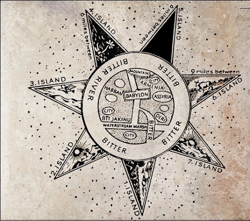
So, the most ancient map of the world is the Babylonian map, which dates back to the beginning of the VI century BC. e. The map was discovered in the XIX century on the territory of Iraq, it is a clay tile with geographical images of three countries - these are Babylon, Assyria and Urartu (Armenia). It is noteworthy that Armenia is marked on the map as the center of civilization with a cuneiform inscription "Urartu-Ararat-Armenia".
The map can be structurally divided into three parts: a graphic card with signatures, text on the front side, as well as on the reverse side. As for the purpose of the clay tile, according to the versions, this tablet was a separate information element, or an illustration to another mythological text or literary work. Thus, all real geographical objects are located within two circles. Circles denote the world's oceans and are literally marked as "salt water" on the map. And the parallel lines depicted inside the circles obviously depict the Euphrates.
- Arts
- Business
- Computers
- Giochi
- Health
- Home
- Kids and Teens
- Money
- News
- Personal Development
- Recreation
- Regional
- Reference
- Science
- Shopping
- Society
- Sports
- Бизнес
- Деньги
- Дом
- Досуг
- Здоровье
- Игры
- Искусство
- Источники информации
- Компьютеры
- Личное развитие
- Наука
- Новости и СМИ
- Общество
- Покупки
- Спорт
- Страны и регионы
- World